
![]() Megjelenés helye Albania - Bulvár és szórakozás - 19 Aug 2024 20:48 - 1
Megjelenés helye Albania - Bulvár és szórakozás - 19 Aug 2024 20:48 - 1
¿Cómo navegamos por el mundo?.
La tierra, este planeta que llamamos hogar, donde casi el 70% de la superficie esta cubierta de agua, y es en el 30% restante donde residimos, estas masas de tierra se dividen en 6 continentes, siendo estos África, América, Antártida, Asia, Europa y Oceanía.
Para desplazarnos por el mundo usamos mapas ya sea digitales o físicos, estos mapas funcionan en base a un sistema de COORDENADAS que corresponden a un sistema de instrucciones que nos permiten determinar la ubicación de un punto sobre la tierra. En esta edición hablaremos sobre las coordenadas geográficas, este sistema está compuesto por 2 elementos obligatorios que son la LATITUD y la LONGITUD y uno opcional ALTURA.
La ALTURA corresponde a la distancia vertical entre un objeto en el aire y el suelo, no confundir con altitud que es la distancia vertical entre un objeto en el aire y el nivel del mar.
La LATITUD corresponde al ángulo formado entre el punto de origen, el centro de la tierra y un punto de la tierra ubicado ya sea al norte o sur del punto de origen, el punto de origen de la latitud corresponde a la línea del ecuador que divide al mundo en hemisferios o latitudes norte y sur.

La latitud “corta” la tierra en discos en líneas PARALELOS al ecuador y se expresa de forma positiva o con la letra N para el norte y de forma negativa o con la letra S para el sur, y sus valores están inscritos entre los 90° latitud norte y los -90° latitud sur.
La LONGITUD corresponde al ángulo formado entre el punto de origen, el centro de la tierra y un punto de la tierra ubicado a este u oeste del punto de origen, donde el punto de origen corresponde al meridiano de Greenwich.
La longitud divide la tierra en meridianos, líneas de norte a sur, que intersecan en los polos, dividen la tierra de forma similar a lo que serian los gajos de una naranja o mandarina, esta línea divide la tierra entre lo que llamamos oriente y occidente, también cumple la función de punto inicial para determinar los husos horarios del mundo, y es su complemento, el meridiano 180° la línea internacional de cambio de fecha.

La longitud se expresa con valores positivos o la letra E hacia el este y con valores negativos o las letras W (ingles)u O (español) para el oeste. Y sus valores están inscritos entre los 0° y -180° oeste y los 0° y 180° este.
Las coordenadas se pueden escribir de 2 formas, Decimal o en Grados y siempre se anota primero la latitud.
La forma decimal se ve así: 40.4530387, -3.6883337
La forma grados se ve así: 40°27’10.937”, -3°41’18.001” que se lee ° grados, ‘ minutos y “ segundos.
Ambas son la misma coordenada.
Dato curioso:
Las coordenadas latitud 0° y longitud 0° se llama NULL ISLAND y corresponde a una boya que ha sido definida como isla de 1m2. Se encuentra en el océano atlántico, frente a las costas de Ghana y Gabón.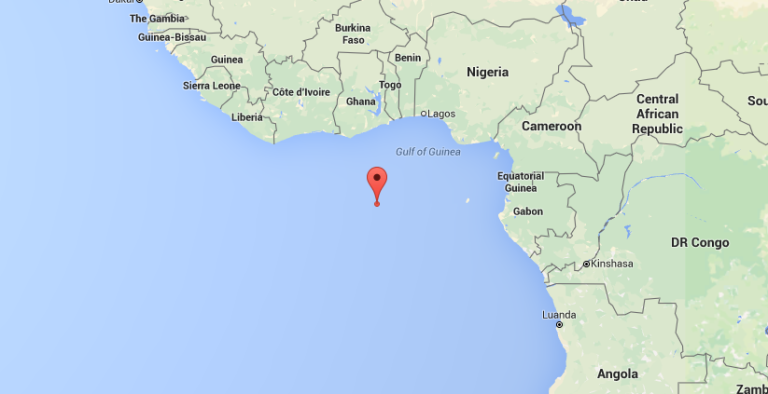
How do we navigate the world?
The earth, this planet we call home, where almost 70% of the surface is covered by water, and the remaining 30% is where we reside, these land masses are divided into 6 continents, these being Africa, America, Antarctica, Asia, Europe and Oceania.
To move around the world we use maps either digital or physical, these maps work based on a system of COORDINATES that correspond to a system of instructions that allow us to determine the location of a point on the earth. In this edition we will talk about geographic coordinates, this system is composed of 2 mandatory elements which are LATITUDE and LONGITUDE and an optional one ALTITUDE.
ALTITUDE corresponds to the vertical distance between an object in the air and the ground, not to be confused with altitude which is the vertical distance between an object in the air and sea level.
LATITUDE corresponds to the angle formed between the point of origin, the center of the earth and a point on the earth located either north or south of the point of origin, the point of origin of the latitude corresponds to the equator line that divides the world into northern and southern hemispheres or latitudes.
The latitude “cuts” the earth into disks in lines PARALLEL to the equator and is expressed positively or with the letter N for the north and negatively or with the letter S for the south, and its values are inscribed between 90° north latitude and -90° south latitude.
LONGITUDE corresponds to the angle formed between the point of origin, the center of the earth and a point on the earth located east or west of the point of origin, where the point of origin corresponds to the Greenwich meridian.
Longitude divides the earth into meridians, lines from north to south, which intersect at the poles, dividing the earth in a similar way to what the segments of an orange or tangerine would be. This line divides the earth between what we call east and west. It also serves as the starting point to determine the world's time zones, and is its complement, the 180° meridian, the international date line.
Longitude is expressed with positive values or the letter E for the east and with negative values or the letters W (English) or O (Spanish) for the west. And its values are inscribed between 0° and -180° west and 0° and 180° east.
Coordinates can be written in 2 ways, Decimal or in Degrees and the latitude is always noted first.
The decimal form looks like this: 40.4530387, -3.6883337
The degree form looks like this: 40°27’10.937”, -3°41’18.001” which is read as ° degrees, ‘ minutes and “ seconds.
Both are the same coordinate.
Fun fact:
The coordinates latitude 0° and longitude 0° are called NULL ISLAND and correspond to a buoy that has been defined as an island of 1m2. It is located in the Atlantic Ocean, off the coast of Ghana and Gabon.
La tierra, este planeta que llamamos hogar, donde casi el 70% de la superficie esta cubierta de agua, y es en el 30% restante donde residimos, estas masas de tierra se dividen en 6 continentes, siendo estos África, América, Antártida, Asia, Europa y Oceanía.
Para desplazarnos por el mundo usamos mapas ya sea digitales o físicos, estos mapas funcionan en base a un sistema de COORDENADAS que corresponden a un sistema de instrucciones que nos permiten determinar la ubicación de un punto sobre la tierra. En esta edición hablaremos sobre las coordenadas geográficas, este sistema está compuesto por 2 elementos obligatorios que son la LATITUD y la LONGITUD y uno opcional ALTURA.
La ALTURA corresponde a la distancia vertical entre un objeto en el aire y el suelo, no confundir con altitud que es la distancia vertical entre un objeto en el aire y el nivel del mar.
La LATITUD corresponde al ángulo formado entre el punto de origen, el centro de la tierra y un punto de la tierra ubicado ya sea al norte o sur del punto de origen, el punto de origen de la latitud corresponde a la línea del ecuador que divide al mundo en hemisferios o latitudes norte y sur.
La latitud “corta” la tierra en discos en líneas PARALELOS al ecuador y se expresa de forma positiva o con la letra N para el norte y de forma negativa o con la letra S para el sur, y sus valores están inscritos entre los 90° latitud norte y los -90° latitud sur.
La LONGITUD corresponde al ángulo formado entre el punto de origen, el centro de la tierra y un punto de la tierra ubicado a este u oeste del punto de origen, donde el punto de origen corresponde al meridiano de Greenwich.
La longitud divide la tierra en meridianos, líneas de norte a sur, que intersecan en los polos, dividen la tierra de forma similar a lo que serian los gajos de una naranja o mandarina, esta línea divide la tierra entre lo que llamamos oriente y occidente, también cumple la función de punto inicial para determinar los husos horarios del mundo, y es su complemento, el meridiano 180° la línea internacional de cambio de fecha.
La longitud se expresa con valores positivos o la letra E hacia el este y con valores negativos o las letras W (ingles)u O (español) para el oeste. Y sus valores están inscritos entre los 0° y -180° oeste y los 0° y 180° este.
Las coordenadas se pueden escribir de 2 formas, Decimal o en Grados y siempre se anota primero la latitud.
La forma decimal se ve así: 40.4530387, -3.6883337
La forma grados se ve así: 40°27’10.937”, -3°41’18.001” que se lee ° grados, ‘ minutos y “ segundos.
Ambas son la misma coordenada.
Dato curioso:
Las coordenadas latitud 0° y longitud 0° se llama NULL ISLAND y corresponde a una boya que ha sido definida como isla de 1m2. Se encuentra en el océano atlántico, frente a las costas de Ghana y Gabón.
How do we navigate the world?
The earth, this planet we call home, where almost 70% of the surface is covered by water, and the remaining 30% is where we reside, these land masses are divided into 6 continents, these being Africa, America, Antarctica, Asia, Europe and Oceania.
To move around the world we use maps either digital or physical, these maps work based on a system of COORDINATES that correspond to a system of instructions that allow us to determine the location of a point on the earth. In this edition we will talk about geographic coordinates, this system is composed of 2 mandatory elements which are LATITUDE and LONGITUDE and an optional one ALTITUDE.
ALTITUDE corresponds to the vertical distance between an object in the air and the ground, not to be confused with altitude which is the vertical distance between an object in the air and sea level.
LATITUDE corresponds to the angle formed between the point of origin, the center of the earth and a point on the earth located either north or south of the point of origin, the point of origin of the latitude corresponds to the equator line that divides the world into northern and southern hemispheres or latitudes.
The latitude “cuts” the earth into disks in lines PARALLEL to the equator and is expressed positively or with the letter N for the north and negatively or with the letter S for the south, and its values are inscribed between 90° north latitude and -90° south latitude.
LONGITUDE corresponds to the angle formed between the point of origin, the center of the earth and a point on the earth located east or west of the point of origin, where the point of origin corresponds to the Greenwich meridian.
Longitude divides the earth into meridians, lines from north to south, which intersect at the poles, dividing the earth in a similar way to what the segments of an orange or tangerine would be. This line divides the earth between what we call east and west. It also serves as the starting point to determine the world's time zones, and is its complement, the 180° meridian, the international date line.
Longitude is expressed with positive values or the letter E for the east and with negative values or the letters W (English) or O (Spanish) for the west. And its values are inscribed between 0° and -180° west and 0° and 180° east.
Coordinates can be written in 2 ways, Decimal or in Degrees and the latitude is always noted first.
The decimal form looks like this: 40.4530387, -3.6883337
The degree form looks like this: 40°27’10.937”, -3°41’18.001” which is read as ° degrees, ‘ minutes and “ seconds.
Both are the same coordinate.
Fun fact:
The coordinates latitude 0° and longitude 0° are called NULL ISLAND and correspond to a buoy that has been defined as an island of 1m2. It is located in the Atlantic Ocean, off the coast of Ghana and Gabon.
Jutalmazás
AeriuzHozzászólások (1)
sub1 vote1 o7
Congrats for your 1st article